Terrain Awareness and Warning System

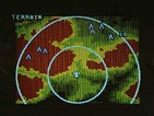
The LandMark TAWS is a remote sensor that can provide a continuous color, birds-eye view of the terrain surrounding an aircraft's position
N/Ak TAWS is a remote sensor that can provide a continuous color, birds-eye view of the terrain surrounding an aircraft's position. It offers a predictive warning function using the position information from a GPS receiver, aircraft configuration and an internal terrain and obstacle database. Both aural and visual warnings are issued whenever potential controlled-flight-into-terrain situations arise. Terrain information can be displayed on a TAWS-compatible ARINC 453 EFIS system or radar indicator. The system also provides visual depictions of obstacles and runways in the area overlaying terrain information.
<%=company%>, 5353 52 St., SE, PO Box 873, Grand Rapids, MI 49588. Phone: 616-949-6600; Fax: 616-285-4224.
