Class B TAWS

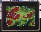
The BFG LandMark TAWS is a remote system that can provide a continuous, color, "bird's-eye" view of the terrain surrounding an aircraft's position
N/AFG LandMark TAWS is a remote system that can provide a continuous, color, "bird's-eye" view of the terrain surrounding an aircraft's position. The system offers predictive warning functions using the position from the GPS receiver, altitude, aircraft configuration and an internal terrain and obstacle database. Both aural and visual warnings are issued whenever potential controlled-flight-into-terrain (CFIT) situations arise.
The system's terrain information can be displayed on a TAWS-compatible ARINC 453 EFIS system or radar indicator. For added flexibility, information can be displayed on existing compatible weather radar indicators using the company's RGC250 Radar Graphics Computer. The system also provides visual depictions of obstacles and runways overlaying terrain information.
<%=company%>, Four Coliseum Center, 2730 West Tyvola Road Charlotte, NC 28217-4578, Tel: 616-285-4361, Fax: 616-285-4223
